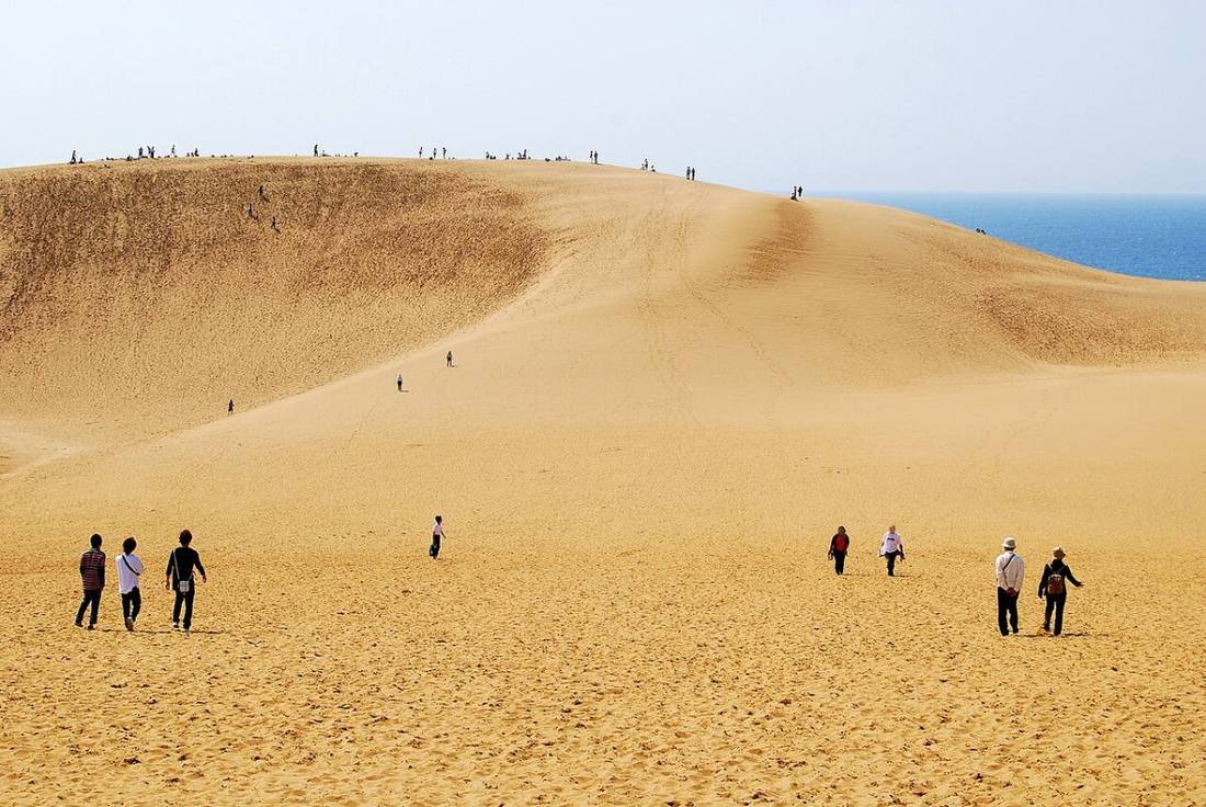
Photo: Hashi photo / CC BY-SA 3.0 · Wikimedia Commons
Tottori Prefecture
Chugoku region · Prefecture
Official website
Tottori Prefecture has the smallest population of any prefecture in Japan. Its specialties are the Tottori Sand Dunes, Mt. Daisen (the highest peak in the Chugoku region), Matsuba crab (snow crab) and Nijisseiki (20th Century) pears. With Mizuki Shigeru Road in Sakaiminato City, it is also loved as a prefecture of yokai (folklore monsters) and manga.
- Tottori Sand Dunes
- Mt. Daisen
- Matsuba crab (snow crab)
- Nijisseiki pears
Key facts
- Municipalities
- 19 (4 cities, 14 towns, 1 village)
Source: Statistics Bureau of Japan, 2025 Population Census (population, area and density); area from the Geospatial Information Authority of Japan (GSI), Area Statistics of Prefectures and Municipalities (2025). National ranks are among the 47 prefectures, ordered by this site from these values.
Places to know
- Tottori City The Tottori Sand Dunes, one of the largest coastal sand dunes in Japan.
- Sakaiminato City Mizuki Shigeru Road and landings of crab at the port.
- Misasa Town Misasa Onsen, one of the world's leading radon hot springs.
Current warnings, advisories and earthquakes
Places to visit in Tottori Prefecture
 Sand dunes · Tottori CityTottori Sand Dunesdunes in Tottori, Japan
 Buddhist temple · Misasa TownNageire-dohall of Sanbutsu-ji temple in Misasa, Tottori Prefecture, Japan
 Castle · Tottori CityTottori Castlecastle ruins in Tottori, Japan
 Buddhist temple · Misasa TownSanbutsu-ji TempleBuddhist temple in Tottori Prefecture, Japan
 Castle · Yonago CityYonago Castlecastle of Japan in Tottori prefecture
 Place of scenic beauty · Misasa TownMt. Mitokumountain in Tottori Prefecture, Japan
 Hot spring (onsen) · Yonago CityKaike Onsenbuilding in Tottori Prefecture, Japan
 Lake · Tottori CityKoyama-ikelake in Tottori, Japan
 Hot spring (onsen) · Misasa TownMisasa Onsenbuilding in Tottori Prefecture, Japan
 Historic site · Yonago CityMukibanda Sitearchaeological site in Yonago, Tottori, Japan
Browse by category
Shrines, temples, castles and historic sites
Chosen automatically, most popular first, from landmarks and cultural properties registered in Wikidata (we have not checked whether each is open). Names and descriptions: Wikidata (CC0); photos: Wikimedia Commons (photographer and license under each photo).
National parks in Tottori Prefecture
Chosen by overlaying the park boundaries (Ministry of the Environment, Biodiversity Center of Japan, "National Park Areas" GIS data, updated April 28, 2025, combined and simplified by NIPPON ATLAS) with municipal boundaries (National Land Numerical Information, January 2021), keeping overlaps of about 0.5 km² or more (approximate). Areas are the land areas from the Ministry of the Environment, "Overview of National Parks" (April 10, 2026). All national parks
Municipalities in Tottori Prefecture (19)
| Municipality | Population | 5-year change | Area | Temperature nownearest AMeDAS |
|---|
| Tottori City | 179,243 | −4.9% | 765 km² | |
| Yonago City | 142,893 | −3.0% | 132 km² | |
| Kurayoshi City | 43,198 | −7.1% | 272 km² | |
| Sakaiminato City | 31,051 | −5.2% | 29.11 km² | |
| Iwami Town | 10,099 | −6.5% | 122 km² | |
| Wakasa Town | 2,338 | −18.4% | 199 km² | |
| Chizu Town | 5,633 | −12.4% | 225 km² | |
| Yazu Town | 14,486 | −9.1% | 207 km² | |
| Misasa Town | 5,343 | −11.8% | 234 km² | |
| Yurihama Town | 15,420 | −4.0% | 77.93 km² | |
| Kotoura Town | 14,756 | −9.8% | 140 km² | |
| Hokuei Town | 13,469 | −5.3% | 56.94 km² | |
| Hiezu Village | 3,487 | −0.4% | 4.20 km² | |
| Daisen Town | 13,937 | −9.3% | 190 km² | |
| Nanbu Town | 9,539 | −7.6% | 114 km² | |
| Hoki Town | 9,741 | −8.9% | 139 km² | |
| Nichinan Town | 3,582 | −14.6% | 341 km² | |
| Hino Town | 2,490 | −14.3% | 134 km² | |
| Kofu Town | 2,368 | −11.4% | 125 km² | |
Source: Statistics Bureau of Japan, 2025 Population Census (population in 2025; change compared with 2020). Area: GSI (2025). Designated cities are shown as one city (wards combined). "Temperature now" is the latest JMA AMeDAS observation (preliminary) at the nearest station in the same prefecture, loaded and shown unchanged when you open the page.