Photo: Wmpearl / CC0 · Wikimedia Commons
Aomori Prefecture
Hokkaido & Tohoku region · Prefecture
Official website
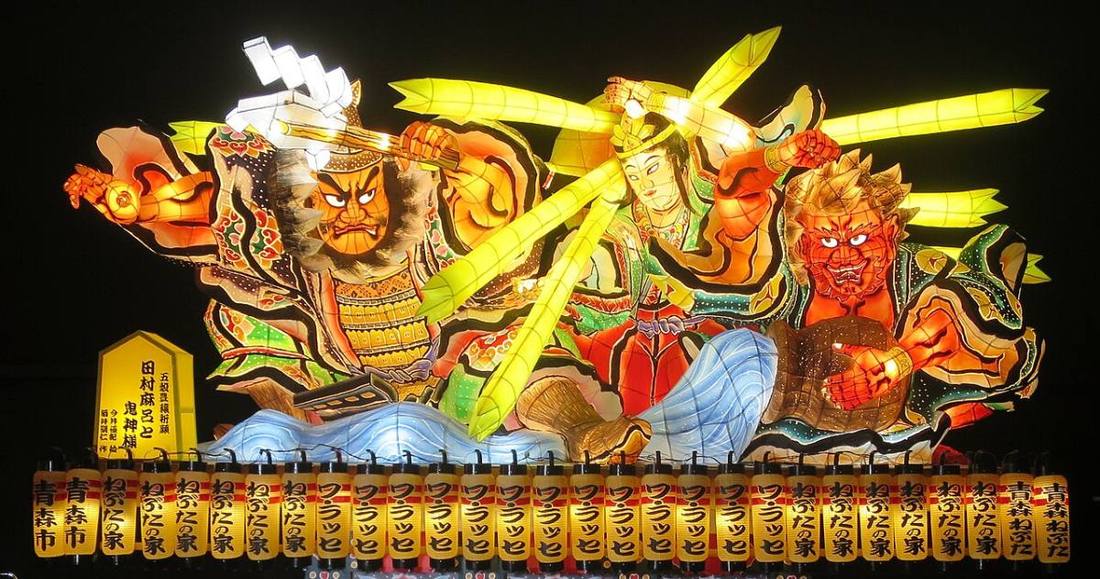
Aomori is at the northern tip of Honshu. It has the largest apple harvest in Japan, and scallops from Mutsu Bay and tuna from Oma are also famous. The summer Nebuta and Neputa festivals are among the liveliest in the Tohoku region.
- Apples
- Nebuta Festival
- Shirakami-Sanchi (World Natural Heritage Site)
- Jomon Prehistoric Sites
Key facts
- Municipalities
- 40 (10 cities, 22 towns, 8 villages)
Source: Statistics Bureau of Japan, 2025 Population Census (population, area and density); area from the Geospatial Information Authority of Japan (GSI), Area Statistics of Prefectures and Municipalities (2025). National ranks are among the 47 prefectures, ordered by this site from these values.
Places to know
- Aomori City The Aomori Nebuta Festival and the Sannai-Maruyama Site.
- Hirosaki City Cherry blossoms at Hirosaki Castle, and the center of apple growing.
- Hachinohe City The largest fishing port in the prefecture, the Hasshoku Center food market and the Hachinohe Sansha Taisai festival.
Current warnings, advisories and earthquakes
Places to visit in Aomori Prefecture
Browse by category
Shrines, temples, castles and historic sites
Chosen automatically, most popular first, from landmarks and cultural properties registered in Wikidata (we have not checked whether each is open). Names and descriptions: Wikidata (CC0); photos: Wikimedia Commons (photographer and license under each photo).
National parks in Aomori Prefecture
Chosen by overlaying the park boundaries (Ministry of the Environment, Biodiversity Center of Japan, "National Park Areas" GIS data, updated April 28, 2025, combined and simplified by NIPPON ATLAS) with municipal boundaries (National Land Numerical Information, January 2021), keeping overlaps of about 0.5 km² or more (approximate). Areas are the land areas from the Ministry of the Environment, "Overview of National Parks" (April 10, 2026). All national parks
Municipalities in Aomori Prefecture (40)
| Municipality | Population | 5-year change | Area | Temperature nownearest AMeDAS |
|---|
| Aomori City | 255,953 | −7.0% | 825 km² | |
| Hirosaki City | 155,880 | −7.5% | 524 km² | |
| Hachinohe City | 205,130 | −8.2% | 306 km² | |
| Kuroishi City | 28,873 | −9.6% | 217 km² | |
| Goshogawara City | 47,462 | −7.7% | 404 km² | |
| Towada City | 56,718 | −6.1% | 726 km² | |
| Misawa City | 37,090 | −5.3% | 119 km² | |
| Mutsu City | 49,674 | −8.2% | 864 km² | |
| Tsugaru City | 27,025 | −12.6% | 254 km² | |
| Hirakawa City | 28,708 | −6.1% | 346 km² | |
| Hiranai Town | 9,121 | −9.9% | 217 km² | |
| Imabetsu Town | 1,888 | −19.1% | 125 km² | |
| Yomogita Village | 2,254 | −11.3% | 80.84 km² | |
| Sotogahama Town | 4,510 | −16.5% | 230 km² | |
| Ajigasawa Town | 7,745 | −14.4% | 343 km² | |
| Fukaura Town | 6,259 | −14.8% | 489 km² | |
| Nishimeya Village | 1,121 | −11.4% | 246 km² | |
| Fujisaki Town | 14,094 | −3.3% | 37.29 km² | |
| Owani Town | 7,601 | −12.3% | 163 km² | |
| Inakadate Village | 6,846 | −6.6% | 22.35 km² | |
| Itayanagi Town | 11,518 | −9.3% | 41.88 km² | |
| Tsuruta Town | 10,750 | −11.0% | 46.43 km² | |
| Nakadomari Town | 8,154 | −15.6% | 216 km² | |
| Noheji Town | 11,173 | −9.7% | 81.68 km² | |
| Shichinohe Town | 13,098 | −10.0% | 337 km² | |
| Rokunohe Town | 9,948 | −4.8% | 83.89 km² | |
| Yokohama Town | 3,818 | −9.7% | 126 km² | |
| Tohoku Town | 14,870 | −9.5% | 327 km² | |
| Rokkasho Village | 10,553 | +1.8% | 253 km² | |
| Oirase Town | 23,652 | −2.6% | 71.96 km² | |
| Oma Town | 4,088 | −13.4% | 52.09 km² | |
| Higashidori Village | 5,189 | −12.9% | 295 km² | |
| Kazamaura Village | 1,381 | −15.6% | 69.46 km² | |
| Sai Village | 1,467 | −18.0% | 135 km² | |
| Sannohe Town | 7,955 | −12.4% | 152 km² | |
| Gonohe Town | 14,318 | −10.7% | 178 km² | |
| Takko Town | 4,343 | −12.6% | 242 km² | |
| Nanbu Town | 15,174 | −9.7% | 153 km² | |
| Hashikami Town | 12,211 | −9.5% | 94.00 km² | |
| Shingo Village | 1,849 | −15.8% | 151 km² | |
Source: Statistics Bureau of Japan, 2025 Population Census (population in 2025; change compared with 2020). Area: GSI (2025). Designated cities are shown as one city (wards combined). "Temperature now" is the latest JMA AMeDAS observation (preliminary) at the nearest station in the same prefecture, loaded and shown unchanged when you open the page.